Mapping the Enlightenment
Intellectual networks and the making of knowledge in the European periphery
A European scholarly flows digital cartography project
The question has not yet been and, most probably, will never be answered. This is a productive difficulty though. The very impossibility of a definitive answer formed the basis for a great number of narratives, which captured the various aspects of a composite historical phenomenon. However, notwithstanding the variety of historiographical approaches involved in these enterprises, there is an impressive consensus as far as the geographical distribution of the Enlightenment is concerned. Most stories are about a limited number of “centers” –primarily gathered in Western Europe–, an equally limited number of “mirrors” –strategically placed in the periphery–, and a “halo” spreading to and differentially assimilated by an extended and still unenlightened periphery.

The last years, the geographies of the Enlightenment have been variously addressed. The main historiographical category involved to depict the circulation of ideas is that of “network”. The networks of the Enlightenment have been reconstituted through the study of the intellectual exchanges among the protagonists of the period. Correspondence, travels, violent displacements, but also the circulation of commodities and scientific instruments have all been used to help historians cope with the complexity of the phenomenon. Within this context, the project Mapping the Enlightenment aims to contribute to further “decentering” the established image of the Enlightenment. The comprehensive information system built for the purposes of this project is able to visualize the itineraries of traveling scholars, and display the building of networks between scientific centers and peripheries throughout the 18th century. Based on the latest developments in digital mapping, the system involves a multi-layered map connected with a travel data base that enable users to query and visualize data and flows through a modern and robust environment.
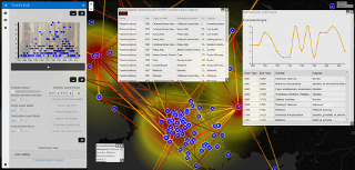
The project does not solely aim at creating visual representations, though. It rather uses digital mapping as a means to organize and display the findings of historical research that challenge the received narrative about early modern intellectual networks in Europe. The intellectual networks developed within and across the European periphery are usually absent from the mainstream narratives of the Enlightenment and if they are present, they are typically treated as the paths of intellectually parochial scholars who were unable to fully embrace the ideal of modernisation through reason and science. Bringing such networks to the forefront, and confirming their role in the production of modern scientific and technical knowledge, may help historians tell more nuanced stories about the complex cultural encounters, which molded the European intellectual space and the multifarious knowledge exchanges that shaped the notion of European science and technology. At present, the project focuses on the intellectual and geographical travels of the 18th-century Greek-speaking scholars, who developed extended networks connecting the most important European educational centers with the power centers of the Ottoman world. Subsequently, it will expand to incorporate data concerning the travels of the Portuguese estrangeirados and Spanish pensionados and will continue to collect and incorporate data about the travels of other scholars from the European periphery.

Our online mapping tool is released! With it, you will be able to get information and map the travels of Greek-speaking scholars during the European Enlightenment Era through a modern interactive environment.

We are pleased to announce the launch of our website. The mapping tool is expected to be online by the end of December 2017. The project was first unveiled to the public in August 2017 at the annual Digital …